Towns
 This page is a directory to the towns served by the
A&Y. I now have photographs of some of the towns, most of the stations, and a
few of the lineside structures along the A&Y from Mount Airy to Sanford. I am finally
getting around to using the list of industries served by the A&Y in the Southern
Railway’s 1916 Shippers Guide. I will be adding the industry type, name and products
shipped in small tables on each town page in the near future. See the one in Ramseur’s
page for an example.
This page is a directory to the towns served by the
A&Y. I now have photographs of some of the towns, most of the stations, and a
few of the lineside structures along the A&Y from Mount Airy to Sanford. I am finally
getting around to using the list of industries served by the A&Y in the Southern
Railway’s 1916 Shippers Guide. I will be adding the industry type, name and products
shipped in small tables on each town page in the near future. See the one in Ramseur’s
page for an example.
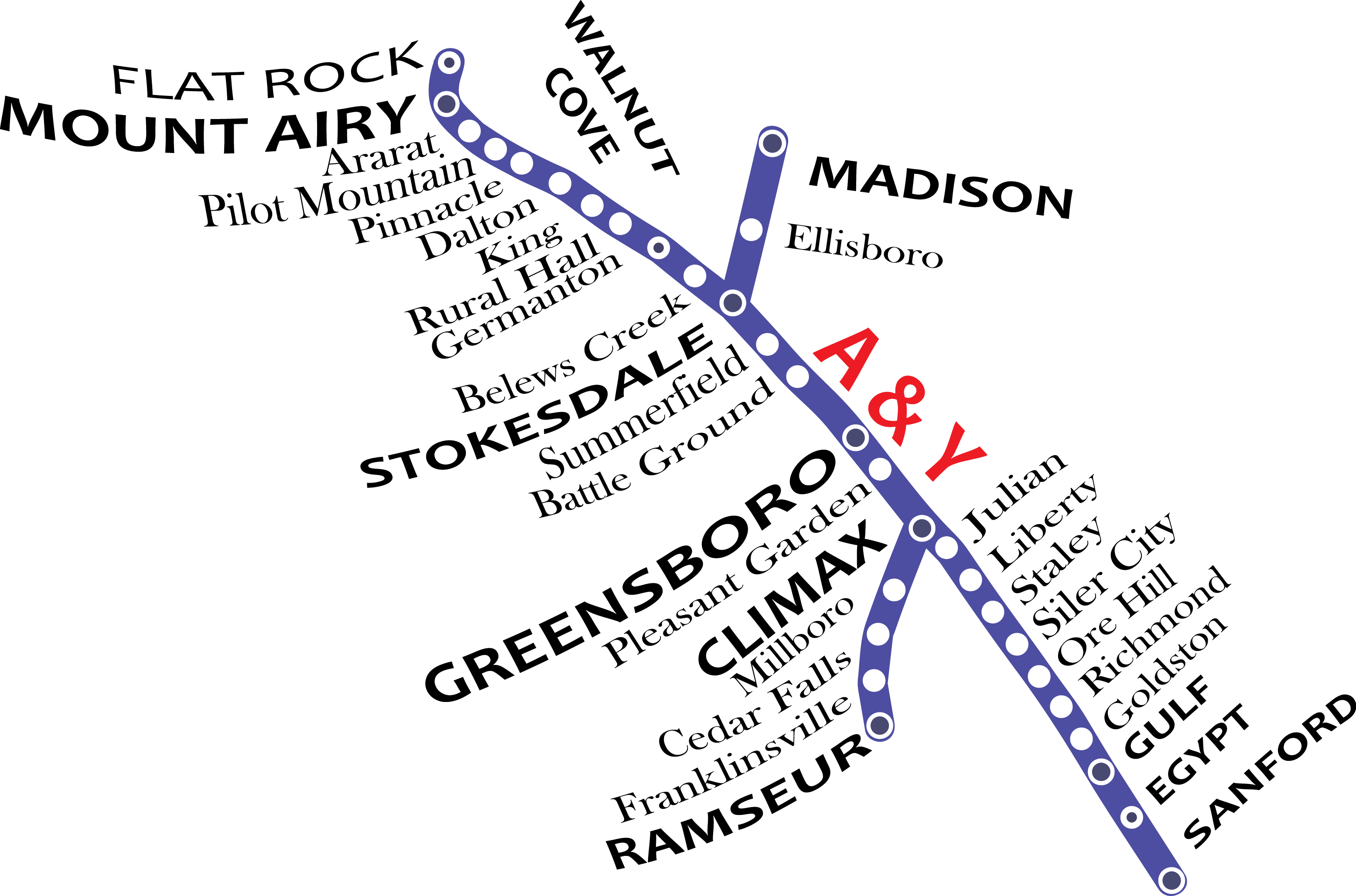
The map image you see was extracted (and then reconstructed by me) from a Cape Fear & Yadkin Valley Railway map from the late 19th century (pre-1895). Some of the town and station stop names have changed since this map was originally drawn. For instance, "Ore Hill" is now called Mount Vernon Springs. Originally incorporated in 1907 this town had its charter revoked in 1913. It was then named after George Washington’s home in Virginia. Another example is "Richmond" whose name changed to Bear Creek in 1895. As you can see there is no Bonlee on this map, even though the town was established in 1894 under the name of "Dunlap’s Mill" and renamed Causey (for Joseph Causey) in 1898. The name Bonlee was not used until 1910. Evidently, the map is old enough that even "Dunlap’s Mill" was not sufficiently populated or developed to be a stop on the CF&YV. Goldston, although it was not incorporated until 1907, was settled by 1885 and must have been sufficiently developed to warrant inclusion on the map. This just goes to show you that maps are tied to the times in which they were made and to the preferences of the map maker!
I have now found track layouts of yards and spurs for each town from the Interstate Commerce Commission’s Valuation Files in the National Archives Research Administration, College Park Maryland. I was able to take digital images of each map in sufficient detail to produce a diagram of the tracks in each town during the Valuation project (1916-1930). An example of these diagrams is currently available on the newest town page: Ramseur.
I am still tempted to order from the Farm Bureau aerial photographs of the region taken during the mid Fifties, but the cost is still a bit much.
Due to the kind of help of many different people--from railroad history buffs to individuals who lived along the line at various times--I have begun to fill the pages for each town served by the A&Y with interesting historical information, maps, industry names and images as I come across them. I really appreciate all the kind words and the helpful hints that visitors to this website have given me!
If you have information about a town served by the A&Y and can share it with me.
PLEASE DO! I hope you enjoy and learn from what I have been able to
find so far.