Cumnock, NC
Lee County · Altitude 259 ft.
History
This community is located in northwest Lee County at an altitude of 259 feet.
The community was named Egypt because large crops of corn produced in the area brought buyers from outside as in the Biblical story of Joseph. The post office name changed to Cumnock in 1895 for an official of the mine.

The photo shows the small combination station, housing both the freight room, agent’s office and passenger waiting area as it was in the 1916–20 era. The station was designated a “type 3” by the ICC Valuation engineer. It was 65' x 30' with a 4' wide platform on ends and 3' wide platform along sides. Exterior walls were board and batten and the roof (overhang of 42" on sides and 24" at ends) had metal shingles in 1916. The platform decking was 2" and the side boards reaching up 2' from ground were 1" wide and vertically placed. The passenger station interior had 7/8" tongue and groove flooring and walls. The fireplace had a plain wood mantle. Freight side had plank floor and 1" boards lining walls up to 4'. It was built in 18xx according to the ICC valuation engineering reports.
The railroad’s reason for being at Cumnock lay underground. The station sat in the Deep River coalfield — the district that gave the place its older name of Egypt — and the 1916 valuation logged the sidings that served it: a spur running to a coal mine, worked by the operating company itself rather than a leased tenant, and another to a brick kiln. The section layout was richer than most, too. Where the surveyors elsewhere dismissed a section dwelling as “identical with Dalton,” they described Cumnock’s first dwelling in full — a larger, hip-roofed house with a thirty-two-foot porch. Cumnock also had the line’s only recorded corn crib, and its depot was the only one on the A&Y with a fireplace of its own. The section tool house, by contrast, was simply “not in evidence, evidently removed.”
Track Diagram
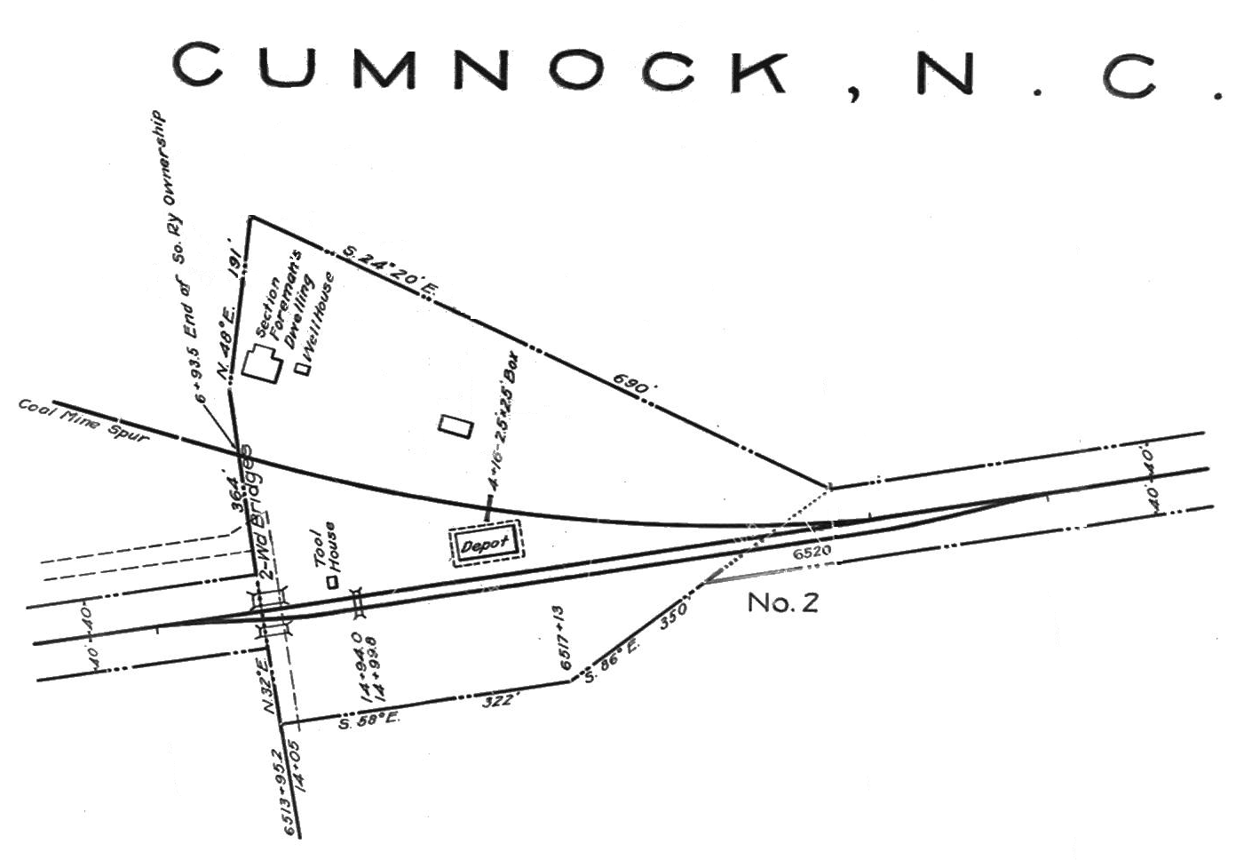
The A&Y tracks at Cumnock had a capacity for 14 cars as of 1943.
Industries
A Southern Railway Shippers Guide from 1916 indicates the following industries were located in Cumnock and using the A&Y for delivering and receiving products by rail (although some may have used the station or team track rather than having a dedicated siding). I will add other industries as I receive information about them:
| Industry | Goods Shipped/Rec’d | Company Name |
|---|---|---|
| brick factory | kiln-burned brick | Goldston Brick Co. |
| cotton gin | cotton | Egypt Imp. Co. |
| flour and grist mill | corn meal | Egypt Imp. Co. |
| livestock | cattle | Egypt Imp. Co. |
| sawmill | pine and oak rough | Egypt Imp. Co. |
| sawmill | pine and oak rough | J.R. Burns |
| sawmill | pine and oak rough | Gough & Arnold Bros. |
| sawmill | pine and oak rough | Henry Shaw |
| sawmill | pine and oak rough | W. H. Gilmore |
| sawmill | pine and oak rough | J. M. Wilcox |
Odds and Ends

Around the station were two employee dwellings similar to those at Dalton. Dwelling #1 was “type 12” sized 25'x36' with a porch, lean-to in back, lapped siding, and double hung plain windows. Dwelling #2 was “identical to dwelling #2 at Dalton.” In addition, the ICC field engineer noted a well, chicken house, corn crib, hog pen, and scrap bin. A tool house was supposed to be there, but was not evident to the engineer and he assumed it was removed. Images are photos of Dalton dwellings by the ICC valuation engineer.

Dalton dwelling #2, pictured here, was identical to dwelling #2 in Cumnock.
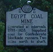
The Egypt coal mine operated from 1855 until 1928 and supplied coal for Confederate blockade runners. In addition to the coal mine, there was an iron works.


Near Cumnock, the A&Y crossed the Deep River on its way to Sanford. These photos show both sides of a road bridge with the newer Norfolk Southern (NS) line: the approach and the crossing of the Deep River on a through truss bridge. This photo shows a scrap gondola dropped off by the Atlantic & Western Railway (ACW).

This photo shows the Norfolk and Southern truss span across the Deep River with the realignment of ex-A&Y track tying in before the bridge. Abandoned in place is the A&Y through truss span a few hundred feet to the west (see photo below). The track is operated by Atlantic and Western Railway from Cumnock (MP CF 123.0) to Brickhaven, with NS as owner. Cumnock to Sanford (CF 123.5 to CF 130.1) is owned and operated by Atlantic and Western Railway from 1995 to present. ACW ends at Gulf and is out of service from Robbins to Gulf. Thanks to Billy Joseph Tucker (ACW GM) for this information!
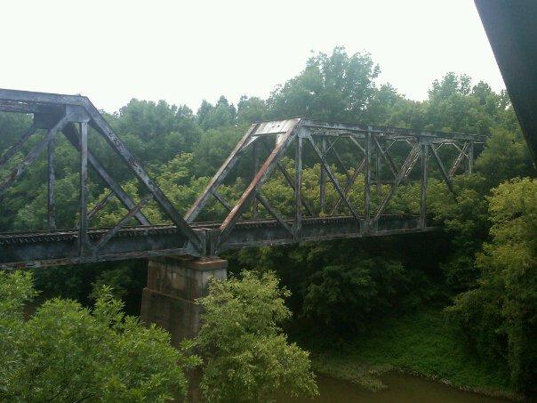
This photo by Billy Joseph Tucker shows the actual A&Y two-span truss bridge abandoned in place.

The corn that attracted all those buyers to “Egypt” must still be produced. There are quite a few active and abandoned feed mills in this area. Here is a shot of the huge Gold Kist chicken feed mill in Cumnock. It is not known whether this mill is serviced by rail, though it is certainly big enough, and it is visible from the road bridge above the Deep River.

This final shot was taken not in Cumnock itself but between this town and Sanford. It is the only good trestle photo available and captures the type of structure that limited the A&Y to lighter motive power. During the steam era, Consolidations (2-8-0 wheel arrangement) were the heaviest power used on the line. Even after the Southern took over and used diesels, there were restrictions on speed and size of locomotives.
If you have any information regarding the history of Cumnock, NC, please contact me.