Up ] Mount Airy ] Ararat ] Pilot Mountain ] Pinnacle ] Dalton ] King ] Rural Hall ] Germanton ] Walnut Cove ] Belews Creek ] Stokesdale and Madison Branch ] Summerfield ] Greensboro ] Pleasant Garden ] [ Climax and Ramseur Branch ] Julian ] Liberty ] Staley ] Siler City ] Ore Hill ] Bonlee ] Bear Creek ] Goldston ] Gulf ] Cumnock ] Sanford ]


Atlantic & Yadkin Railway

History &
Modeling


Millboro
Cedar Falls
Franklinville
Ramseur

Climax (milepost CF 82.2)

History

This community in southeast Guilford County is at an altitude of 824 feet above sea level. It was established in 1853 and named for its location on high ground.   In the days of the A&Y, the town was on the CF line where it curved from its southeastern direction out of Pleasant Garden to head directly east for a short while before turning southeast again to Liberty. Just after the turn east Climax was located near the junction with the CR line to Ramseur. In 1934, the A&Y employee time table indicated that Climax trackage could hold 19 cars.

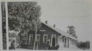
AY_station_icc_climax_1918_01.jpg (126289 bytes) The ICC Valuation documents included this photograph of the Climax station.

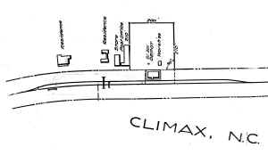
Track Diagram  

bw_v27-22_climax01.jpg (87989 bytes)


Industries

A Southern Railway Shippers Guide from 1916 indicates the following industries in addition to LCL shipments, passengers, and mail were located in Climax and used the A&Y for delivering and receiving products by rail (although some may have used the station or team track rather than having a dedicated siding). I will add other industries as I receive information about them:

Industry

Goods Shipped/Rec'd

Company Name

cotton gin cotton M. L. Allred & Bro.
sawmill oak, pine, poplar Greyson Lumber Co.


Odds and Ends

Some of the buildings from the A&Y era still exist.
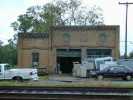
climax_post_office_allred_and_sons Here's a photo I took of the building that housed the Climax post office and M.L. Allred and Son. This building as you can see faces the tracks.
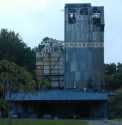
climax_security_feeds_millclimax_security_feeds_mill_b Here are a couple of photos of the Security Feed Mills, another of the ubiquitous feed mills in the region. At first, I thought this mill was abandoned, but the vehicles parked in front made me rethink that conclusion.  The state of the rail spur suggests that NS does not serve it anymore, though the A&Y and maybe the Southern probably did.
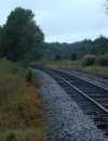
climax_track I am including the shot in Climax below to help modelers get a feel for the countryside through which the A&Y ran.  Remember this was a rainy cloudy day.   You'll have to look at the shots of towns north of Greensboro to see what the countryside looks like on a sunny day.


This website is copyrighted 1998-2022 by David M. Bott.  Images appearing on this website may be protected by U.S. Copyright Law, donor restrictions, and other rights or policies. The Railroad Roman font used in the title was bought from Ben Coifman. Persons who contemplate copying and using font or images should obtain all necessary permissions pertaining to use. Authorization to use images credited to the North Carolina Collection, University of N.C. Library at Chapel Hill should be sought from the Collection at CB#3934, Wilson Library, University of North Carolina at Chapel Hill, Chapel Hill, NC 27514-8890. Telephone 919-962-7992. Images credited to the North Carolina State Library Photo Archives are considered in the public domain.  Images credited to others or unknown are subject to copyright restrictions and permission for use should be obtained.

This page  last edited Wednesday, October 05, 2016