Cedar Falls
Cedar Falls (milepost CR 14.1)
History
This community in central Randolph County was incorporated in 1899 but repealed it’s charter in 1901. Once known as Everrett’s Mill for Colonel Benjamin Everrett.. In 1943, Cedar Falls trackage could hold 9 cars, although the employees’ timetable also lists Cedar Falls Factory at milepost 13.6 which may have held more cars.
The station at Cedar Falls was relatively significant on the Ramseur branch. In 1912, there was a money order Post Office and the station agent also acted as the agent for the Express Company. There was a spur siding located at the station, probably for loading and unloading express and less-than-carload freight.
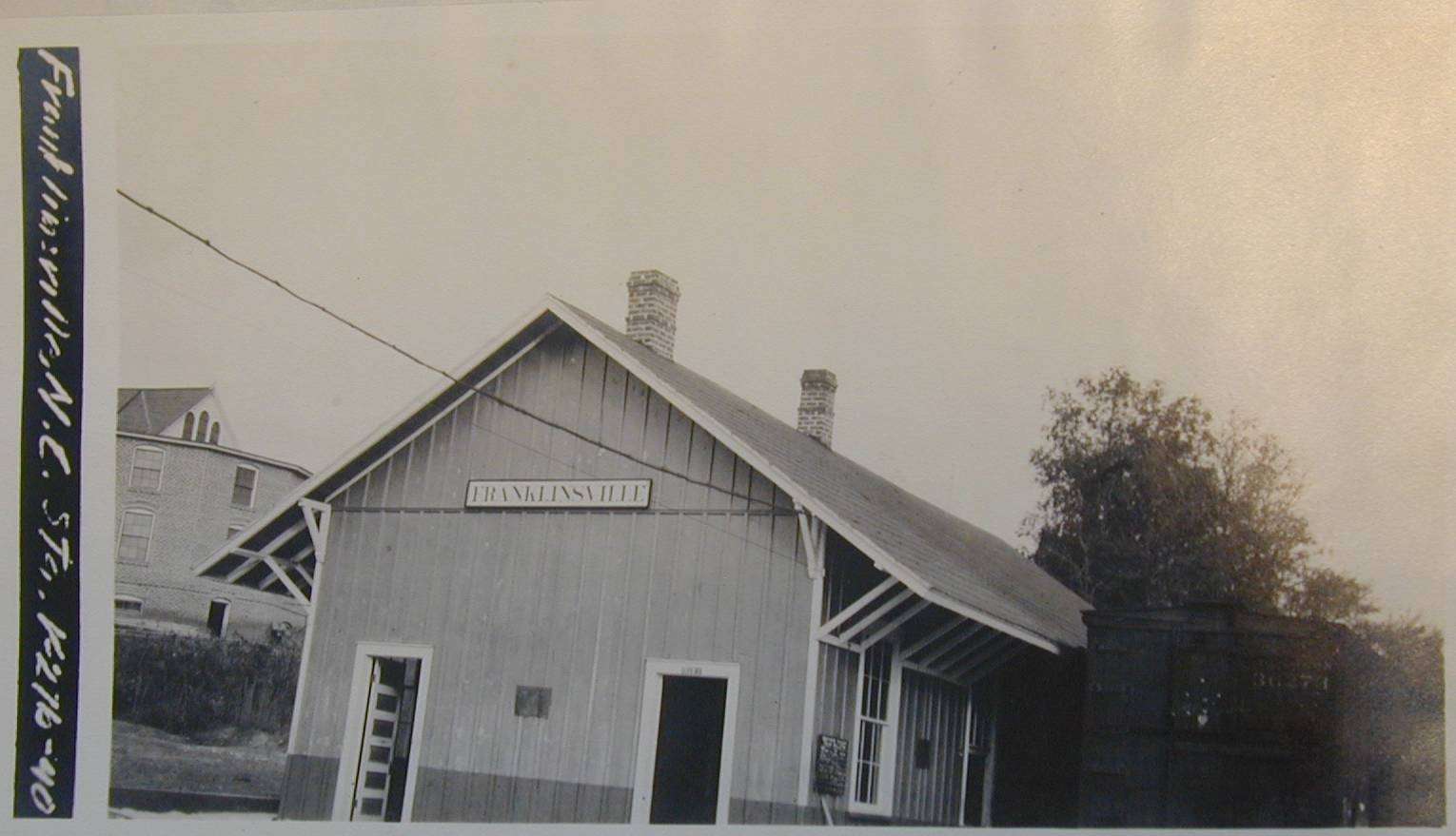 On
the right is a photo of the station circa 1918 from the ICC Valuation reports. Click
on the thumbnail for a large image. The ICC valuation engineers reports, dated 1916,
indicate that the station was 40x23 with a 28x32 extension platform. The roof overhang on
the sides of the station were 4' 6" and 2' on the ends. The station had gable
roof heights of 13'3" on passenger and 23'3" on freight section. The
construction was known as a "Type 3" with board and batten siding and metal
shingle roof. The passenger interior was 7/8" tongue and groove. The
freight room was lined 5' high with 1" boards and had a 2" plank floor.
Platforms of 2" decking were all around the station, 3' high and boarded up on sides
with 1" boards. The platform light in 1918 was a "Dietz ‘Pioneer’ oil
station lamp 6"x6"x8' post.
On
the right is a photo of the station circa 1918 from the ICC Valuation reports. Click
on the thumbnail for a large image. The ICC valuation engineers reports, dated 1916,
indicate that the station was 40x23 with a 28x32 extension platform. The roof overhang on
the sides of the station were 4' 6" and 2' on the ends. The station had gable
roof heights of 13'3" on passenger and 23'3" on freight section. The
construction was known as a "Type 3" with board and batten siding and metal
shingle roof. The passenger interior was 7/8" tongue and groove. The
freight room was lined 5' high with 1" boards and had a 2" plank floor.
Platforms of 2" decking were all around the station, 3' high and boarded up on sides
with 1" boards. The platform light in 1918 was a "Dietz ‘Pioneer’ oil
station lamp 6"x6"x8' post.
The ICC reports suggest that the station oil house was of a standard design built from a print dated 1905. The station outhouse was 4'x6'x7'4" with shed roof. In addition to the station, oil and out houses, there were several dwellings belonging to the railroad in Cedar Falls. I do not have photos of them, but the engineers described them in their reports and you can see their outline and locations relative to the track and depot in the track diagram below. The section house was located behind the depot and just to the north. There is not much description other than it is similar to the section house #1 in Dalton and that it had a metal shingle roof. The other residence was located down the tracks south of the depot. It was considered to be identical to dwelling #2 in Dalton and again it had a metal shingle roof.
Finally the engineers describe a pig pen, fencing and the tool house at Cedar Falls. The fencing was built from chickenwire, 48" high and hung on split rail fence posts planted 2' into the ground. The tool house was 10x12 with a 11'6" gable roof. The house was "identical with toolhouse at Dalton, NC."
Track Diagram
An image from the ICC valuation maps gives a fair idea of how the track and depot were laid out. Click on the thumbnail to view a larger detailed image. Note how the station faced the Deep River across the tracks. The 1912 track profile of this branch indicates that a gravity water tank was located milepost CR 13.8. The Cedar Falls factory spur was located at CR 13.6. Note also, the dam and mill race that powered the Cedar Falls textile mill.

Industries
A Southern Railway Shippers Guide from 1916 indicates only one industry, The Cedar Falls Manufacturing Company, located in Cedar Falls and using the A&Y for delivering and receiving products by rail (although some may have used the station or team track rather than having a dedicated siding):
| Industry | Goods Shipped |
Company Name |
cotton mill |
Cotton Cloths |
The Cedar Falls Mfg. Co. |
Odds and Ends
Here are some photos (click on the thumbnail photos to see a larger image). I took a few on my trip in September 1999. The first photo below was sent me by Mr. Eddie Clay Allred, a charter member of the Franklinville Historical Society.
 Mr. Allred
has the following information regarding this image: "A
train wreck happened about 500 yards West of the original Cedar Falls Cotton Mill in the
Long Curve just before the track crossed the water race that routed around the back of the
Mill(north side)! This is all we know about this photo but suspect it relates to the
Atlantic & Yadkin Railroad!"
Mr. Allred
has the following information regarding this image: "A
train wreck happened about 500 yards West of the original Cedar Falls Cotton Mill in the
Long Curve just before the track crossed the water race that routed around the back of the
Mill(north side)! This is all we know about this photo but suspect it relates to the
Atlantic & Yadkin Railroad!"
The first cotton mill in the county, Sapona Cotton Mill, was built here in 1836. Here is an historical marker indicating this (no larger image is available of this sign):
These two shots show a modern textile mill in Cedar Falls.


I have no idea if this mill is or was part of the Sapona Cotton Mill or part of another
company. I’m also not sure this mill is still in business.
In addition the mill, I have a photo of the Cedar Falls post office.
Back side, facing the road and front side apparently facing the trees!


According to Gareth McDonald, who provided a narrative tour of the A&Y lines for me in September, 1999, the reason for the strange orientation of the building is that the railroad used to run behind this building up in the area that is now forested. Therefore the building, once a store as well as a post office, would have FACED the most important means of transportation in the early 20th century: the railroad!
The final image I have for this area is not connected directly with the railroad, but is certainly typical of the region served by the Atlantic & Yadkin Railway, a tobacco barn:

These are all the images I have for now. Hopefully Mr. Allred and the rest of the local historical societies in the region will have more information for towns served by the Ramseur branch of the A&Y in the near future!