Liberty, NC
Randolph County · Altitude 790 ft.
History

Liberty, altitude 790 feet, is a town in northeast Randolph County. It was incorporated January 30, 1889 and was named for the nearby plantation of John Leak who settled there in 1807. The area was first occupied by the Catawba Indians, a branch of the eastern Sioux tribe. During pre-Revolutionary War days, German, Scotch-Irish and English colonists settled in this area. Early references to a town called “Liberty” are mentioned in land transactions in the year 1809 to be found in preserved official records on file at Randolph County Courthouse in Asheboro. It is because of these findings that Liberty’s town seal bears a picture of the “Liberty Oak” and has 1809 as a founding date, although the charter date is 1889. A rich part of Liberty’s history is contained in the educational life of the community. As early as 1886 the Liberty Academy began operation. The school was supported by tuition paid by the students. At this time Liberty was known as an educational center and farming community. The railroad was the vital link that turned Liberty into a town, and the Cape Fear & Yadkin Valley Railway in its 1889 publication referred to Liberty as a place “where many contemplated and actual improvements evince a spirit of progress and enterprise. A fine school is established here, which for discipline and curriculum of study has already taken high rank among educational institutions of that section.” You can learn more about the town at the Liberty official web site.
Liberty’s depot stood a cut above its neighbors. Where the smaller stops up and down the line got the standard Type 3 wooden combination station, the 1916 ICC valuation recorded Liberty as the first Type 5 station on the A&Y — a larger plan (Southern Railway print No. 15-143) set on brick piers, with a high wood platform along the end and one side of the freight room. Its chert passenger platform ran to about 590 square yards, edged with some 800 feet of heavy wood curb — one of the largest platform allowances in the southern half of the line. Liberty also carried the line’s first Type 14 tool house, built to a standard plan dated 1901. One small detail speaks to how the section crews made do: by 1916 the second section dwelling was no longer a home but a feed store house kept by the section foreman.
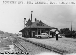
A photo of the Liberty station in 1962, 12 years after the A&Y was formally absorbed into the Winston-Salem division of the Southern Railway.

An earlier photo of the Liberty station, although the date is unknown. This is likely an R.D. Connor photo.

Recently, the station at Liberty was moved from its original site to the other side of the tracks and a preservation effort has begun. This is a contemporary photo of the station in its new location.
Track Diagram

In 1943, Liberty’s tracks had a capacity for 28 cars and had yard limits and a telephone. There is evidence of at least two section houses and a ways down the track there was a wood water tank near milepost CF 95 that was originally kept full with a steam pump and later with an electric pump.
Industries
A Southern Railway Shippers Guide from 1916 listed fourteen industries in Liberty using the A&Y for delivering and receiving products by rail (although some may have used the station or team track rather than having a dedicated siding). The ICC valuation map depicts the location of the Liberty Chair Company. I will add other industries as I receive information about them.
| Industry | Goods Shipped/Rec’d | Company Name |
|---|---|---|
| brick factory | bricks | Liberty Brick Co. |
| cotton gin | cotton | Home Lumber Co. |
| flour and grist mill | feed | Liberty Feed Co. |
| flour and grist mill | feed and flour | Liberty Milling Co. |
| grain and hay dealer | grain | Liberty Milling Co. |
| harness factory | harnesses | J. A. Kirkman |
| livestock | miscellaneous | Wade Hardin |
| sawmill | oak and pine | R. D. Patterson |
| sawmill | oak and pine | B. J. Gregson |
| sawmill | oak and pine | A. M. Fogleman |
| sawmill | oak and pine | Staley Lumber Co. |
| sawmill | oak and pine | Home Lumber Co. |
| sawmill | oak and pine | Foster & Pickett Lumber Co. |
| woodworking factory | picker sticks | Liberty Picker Stick & Novelty Co. |
Odds and Ends
Here I will include any information that is non-railroad in nature that helps provide a hint as to the character of the people and industries who lived and worked in Liberty. I welcome any and all information about this former A&Y community!

A photo post card found on eBay that shows Swannanoa Street in Liberty, likely in the teens or 20s given the vehicles. You can see railroad crossbucks marking the A&Y down the street in the full size version.

Some shots of the downtown near the station and tracks. This first shot is of the Liberty Hardware store.

Another structure, this one trackside but south of the station. It looks like it could have been there in the 1950s.

The water tower certainly looks like it could be from the middle of the century when the A&Y was still active.