Walnut Cove, NC
Stokes County · Altitude 634 ft.
History
Walnut Cove is a town in south Stokes County. It was settled in 1883 and known as Lash until 1889 when it was incorporated under its present name. It was named for a grove of walnut trees. Stokesburg, formerly a separate community just south of Walnut Cove, is now within the corporate limits. For more history, visit the Walnut Cove town web page. Walnut Cove is at an altitude of 634 feet.

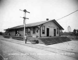
I have a photo of the A&Y station at Walnut Cove courtesy of the Farrell brothers. I believe that may be the Stokes County warehouse in the right foreground. I have a photo from the other direction of the store on the left (see below).
Peter took this photo, Roger saved it, and sent the negatives for this and several other photos (522, 109, and more of this crossing) to me to share on this site. Fortunately, the negatives were saved from the fire, although the prints sent along were lost. This image is from a scan of the negative.
From the ICC engineering field notes, I know it was a “Type 3” combination station built in 1887 for the CF&YV. It was 50’x30’ with a passenger platform surrounding it entirely. The platform was 6’ wide along the front and back sides and 8’ wide along the two ends. The platform was 4’ high and boarded up with 1” boards applied vertically. The interior of the combination station was divided into a baggage area 29’6” long by 30’ wide and a passenger area with office was 20’ 6” long and 30’ wide. The station walls were a board and batten type, measuring 13’ 3” tall. The gable roof peaked 19’ 9” above the ground but extended over the platform. The roof was made of metal shingles at that time. Two Dietz pioneer oil lamps on 10’ high 4x4 posts were used to light the exterior.
The depot area also contained an oil house and privy. The track section also contained two section dwellings, a barn, a toolhouse and several material bins. The section houses were identical to those at Dalton.
Track Diagram

In 1943, the A&Y had a crossing at grade (interlocked) with the Norfolk & Western Railway (the railroad that served most of the town’s industries). The A&Y had a yard with a capacity of 90 cars, a wye, and a phone in Walnut Cove.
Industries
A Southern Railway Shippers Guide from 1916 indicates the following industries in addition to LCL shipments, passengers, and mail were located in Walnut Cove and used the A&Y for delivering and receiving products by rail (although some may have used the station or team track rather than having a dedicated siding). I will add other industries as I receive information about them:
| Industry | Goods Shipped / Rec’d | Company Name |
|---|---|---|
| brick factory | bricks | Hedgecock Brick Co. |
| brick factory | bricks | M. A. Walker Co. |
| flour and grist mill | flour and meal | Walnut Cove Roller Mill |
| sawmill | pine lumber | Matthews & Johnson |
| staves & heading mill | dressed lumber staves & heading | Dan River Lumber Co. |
Odds and Ends
Today, the N&W tracks are part of the Norfolk Southern line, but the crossing and the A&Y tracks are long gone. Not much to see today, and I didn’t take any photos.
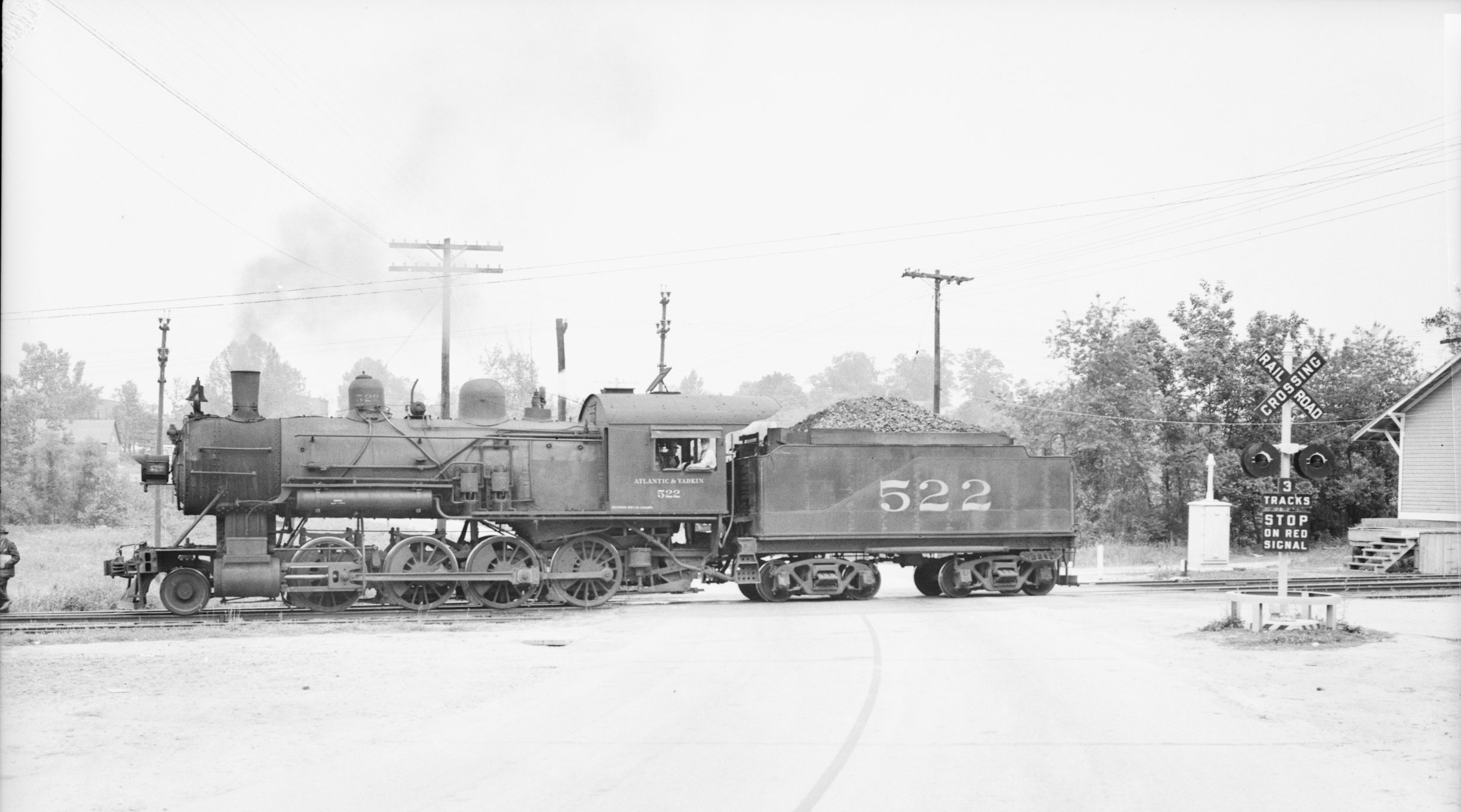
This photo by Peter Farrell may be my favorite all time. It depicts the 522 crossing the street just past the Walnut Cove depot. There is either a brakeman or crossing flagman on the far left (partially cut off). Mr. Farrell took a number of photos from different vantage points that day, and I would like to model the station and road crossing in a diorama or as part of my layout.

From this view we get to see Dodson’s Grocery on the right and what appears to be some kind of warehouse or storage building on the left (same building as on the right in the station photo above). If you look very carefully just beyond that building on the left is a Reading single sheathed boxcar sitting on the N&W tracks behind the trees. You can see the crossbucks for the N&W grade crossing in the center distance.
The other store in the station picture above is partially obscured behind Dodson’s. Note the signal box in the foreground and the fairly modern flashing crossbuck sign in the middle. That suggests a 1940s timeframe. The war poster on the building behind Dodson’s suggests at least ’42. Photo is also by Peter Farrell.

From this view we can confirm the Walnut Cove name on the station. We can also see a horse and wagon coming over the bridge crossing Town Fork Creek. There are two billboards with advertising beyond the bridge, but the resolution won’t allow me to determine what they might say. Beyond the creek appears to be a ridge or hill with part of the town on it.

This photo is taken slightly further up the road (to the right is the road to the N&W depot) so that you can see that other building has a sign indicating an “inn” as well as a Coca Cola advertising sign. Dodson’s advertises Pepsi, Budweiser, and Atlantic Ale (the painted partial sign on the wall of the grocery). From this distance, the A&Y station is further away, but you can just spot a late 30’s or early 40’s auto parked at the end of the station. Given the track layout, Peter Farrell must have had his camera almost on the N&W tracks to his back as he took this photo.

And now, let’s focus on Dodson’s Grocery to see how we might model that interesting structure.
Given the multiple viewpoints in the photos, a diorama would be fairly easy to design. The signs you see on Dodson’s are easy to replicate after a quick internet image search. See the Red Top Beer, Pepsi Cola, 7-UP, Annheiser-Busch Budweiser, and Atlantic Ale sign images that I can use to help model Dodson’s.


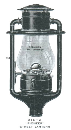
An internet search revealed W.T. Kirkman’s Lanterns Incorporated, where the Dietz lamps mentioned in the ICC valuation engineering notes are described:
Dietz introduced the #3 Globe Tubular Street Lamp in 1880, and in 1906 it was redesigned and renamed “Pioneer.” Dietz first introduced the electric version of the “Pioneer” in 1915. Over the years the electric version of the Pioneer has had two major revisions; The air tubes were abbreviated, and the tapered post fitter was retooled for standard 3″ lamp post [as in the photo to the left]. Production of the kerosene “Pioneer” was discontinued in the 1940’s, and is no longer available.
Although the Dietz Pioneer is no longer available, Dietz continues to sell lamps made in China today.
From other station photos along the A&Y, I’m guessing that the Dietz Pioneer Lanterns in use at the stations were the kerosene type and were removed when electrification of the station was completed. These were very large, standing 25+ inches tall.
The Virginia Tech Library has a photo of the N&W depot in Walnut Cove ca. 1910 from the Norfolk Southern collection. More information is available at the Virginia Tech imagebase. Is that the corner of the A&Y depot cut off on the left hand side? If you look at the track diagram above, there is a very good chance it is.